The Weather Channel reports:
Hurricane Milton will make landfall in Florida tonight into early Thursday where it poses a major threat to life and property as it hammers the state with destructive storm surge, devastating wind damage, potentially catastrophic flooding rainfall and several tornadoes.
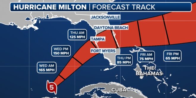
“The track of Hurricane Milton continues to be a worst-case scenario for the Tampa Bay region southward to Charlotte”, the National Weather Service in Tampa Bay said in a briefing Wednesday morning. This is a life-threatening situation and all evacuations and storm preparations should be rushed to completion.
Milton is a Category 5 hurricane packing winds up to 160 mph as of 7 a.m. EDT. It is centered 300 miles southwest of Tampa and is tracking to the northeast at 14 mph.
The Tampa Bay Times reports:
Tampa Bay residents woke up Wednesday on the razor’s edge of a nightmare scenario as Hurricane Milton churns closer to the Gulf Coast.
As the potential area for landfall tonight or early Thursday narrows, storm-weary residents are bracing for the worst. Surge may reach up to 15 feet. Power could be out for weeks. The worst of Milton’s impacts could be decided by slight shift in its track.
The Tampa Bay region is under a hurricane warning and a storm surge warning. Pinellas and Pasco counties have issued mandatory evacuations for zones A, B and C and all mobile and manufactured homes. Hillsborough has ordered evacuations for residents in zones A and B and all mobile and manufactured homes.
The Associated Press reports:
Heavy rain was beginning to spread across parts of southwestern and west-central Florida ahead of Milton early Wednesday, and weather conditions were expected to deteriorate across parts of the Florida Gulf Coast throughout the day, the center said.
Six to 12 inches (15 to 31 centimeters) of rain, with localized totals up to 18 inches (46 centimeters), were expected across central to northern portions of Florida through Thursday, bringing the risk of catastrophic and life-threatening flash and urban flooding, and moderate to major river flooding.
Several tornadoes were likely Wednesday across parts of central and southern Florida. Forecasters predicted the storm will retain hurricane strength as it crosses central Florida on Thursday on a path east toward the Atlantic Ocean.
Video below is live.
🌀5AM 10/9 Update: #Milton is expected to make landfall at a Category 4. We can expect to see hurricane force winds at 9pm tonight, landfall of the eye expected around 2am. pic.twitter.com/liSZSwgHYg
— City of Tampa (@CityofTampa) October 9, 2024