USA Today reports:
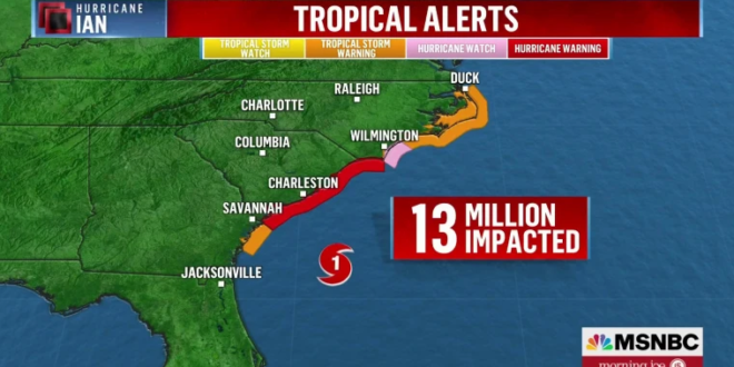
Ian strengthened back into a Category 1 hurricane late Thursday and was set to make landfall Friday afternoon on the coast of South Carolina before moving inland across the state and into North Carolina by Saturday. Heavy rains and tropical storm conditions had already reached the coasts of Georgia and the Carolinas by Friday morning, where life-threatening storm surge and hurricane conditions were expected to develop.
Greenville’s NBC affiliate reports:
The latest track shows the storm making landfall between Charleston and Myrtle Beach, then moving north. Strong winds will hammer South Carolina and Georgia’s coasts into Friday afternoon. Gusts of up to 90 mph will be possible as Ian makes its second landfall along the SC coast. North Carolina’s coast will have strong winds with a slight chance of severe weather, but the strongest winds stay south. Storm surge of 2-5 feet is possible Friday.
As damage to southwest Florida came into clearer view, Ian moved out over the Atlantic Ocean and strengthened again into a hurricane. The storm is expected to make landfall on Friday in South Carolina.
Here’s what to know.https://t.co/yboaGhtkMc
— The New York Times (@nytimes) September 30, 2022
Satellite & radar simulation for #Ian. Showing landfall in South Carolina just north of Charleston. Likely 80-90mph winds at landfall. Rain shield then moves north to DC by Friday evening. DC could see 30-40mph gusts Friday night. Saturday, on & off showers. Sunday looks soggy. pic.twitter.com/7aP99V6B3p
— Mike Thomas (@MikeTFox5) September 30, 2022
There is a danger of life-threatening storm surge from #Ian through Friday along the coasts of northeast Florida, Georgia, and South Carolina.
Follow any advice given by local officials. pic.twitter.com/SYsJuOyLOe
— National Weather Service (@NWS) September 30, 2022
Hurricane-force winds are expected across coasts of South Carolina and southeastern North Carolina beginning early Friday. Be ready for tree damage. #Ian pic.twitter.com/AMLqg1ZR2I
— National Weather Service (@NWS) September 30, 2022